|
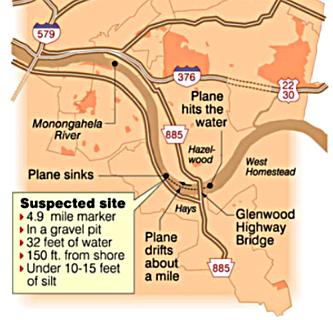
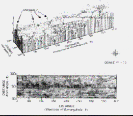
A PITTSBURGH TOAST 2024 Announcement - Help the search for the B-25... One of Pittsburgh's Historic Mysteries At 4:10 P.M., on January 31, 1956, a TB-25N medium bomber ditched in the Monongahela River (locally known as the "Mon") near Homestead, Pennsylvania, and was lost. All six of the occupants aboard the aircraft survived the ditching. Only four, however, survived their encounter with the freezing Mon. In the fourteen days following the ditching, a search for the aircraft was conducted but the B-25 was never found and its fate remains one of Pittsburgh's most intriguing, enduring and challenging mysteries. In 1995 the B-25 Recovery Group, headed by John Uldrich, started a scientific investigation that has carefully pieced together the story of what really happened on the 31st of January and the days that immediately followed. Since 1995 the Group has mapped the bottom of the Mon with side-scan sonar and gathered documentation on the ditching from government and civil sources. The Group has also interviewed experts on subjects ranging from the design and construction of the B-25 bomber to silt deposition in the Mon. Based on their findings, the Group has determined that the bomber was never spirited away by the Army on the night of the 31st as some people claim. Rather, through a document chain of events, the bomber accidentally slipped into an open gravel pit under the water and was quietly buried by the river. If the B-25 wasn't taken from the river, then where is it? Based on the Group's research, the B-25's is buried approximately 150 feet off the left descending bank of the Mon, at mile point 4.9, at a place know to river men as Bird's Landing. Bird's Landing was once a tie-off spot for barges. Bird's Landing was also a favorite stopping place for "gravel pirates" who dredged gravel from the river and sold it to customers along the Mon, Allegheny and Ohio rivers. It was the activities of these entrepreneurs that created the open pit that would eventually be the burial site of the B-25. Somewhere in that filled in gravel pit, under 32 feet of water and 15 feet of silt lay the remains of In December of 1997, the Group requested and received assistance from the US Army Corps of Engineers (Pittsburgh District) and the State of Pennsylvania in protecting the river bottom off of Bird's Landing from activities that would disturb the bottom of the river and possibly destroy any remains of the aircraft. The support of the Army Corps of Engineers and the State of Pennsylvania will ensure that the site remains intact until the right equipment and resources are available to conduct a through exploration of Bird's Landing site. How will the Group confirm that the bomber is there? Through careful research, Mr. Bob Shema has determined that a metal detecting magnetometer is the the best sensor to be use in locating the remains of the bomber. After 44 years of being subject to the varying pH (acid) concentrations, river traffic and pressures associated with burial, Bob Shema believes this non-intrusive sensor has the best chance of of locating an aircraft in a fragile and corroded state. Once a potential target is located, selective excavations will be conducted to confirm the bomber's presence. Evidence of the bomber will likely be small samples of of metal collected during the excavations. These samples will then be analyzed to confirm that are the same materials originally used in the construction of the aircraft. If evidence exists that the aircraft is intact (unlikely), an effort may be mounted to recover part or all of the bomber. Why isn't the Group working on finding the bomber now? Confirming the bomber's presence is an expensive proposition. The cost of technical support, boats and renting the magnetometer comes to just over $25,000.00. It's a high price - but it's the only realistic way of tackling Bird's Landing without a destructive dredging operation. Your donations will help the Group get the equipment and technicians needed to confirm the bomber's presence. Bottom line - your financial support is needed to complete this project and solve one of Pittsburgh's great historic mysteries!
Making Contributions - Matching Program If you are interested in making a contribution in honor of John Uldrich and to help the efforts of the B-25 Recovery Group. You can either make a donation via a PayPal account or credit card by using PayPal and sending funds to steve@sennex.com make a note for the B25 Group. You may also mail a check to: Steve Byers fbo The B25 Group Note: contributions are not a tax deduct by rules of non-profit charitable organization qualification. All Funds will be matched by Steve Byers and or other members of the group and used for the efforts of recovering the B-25. |
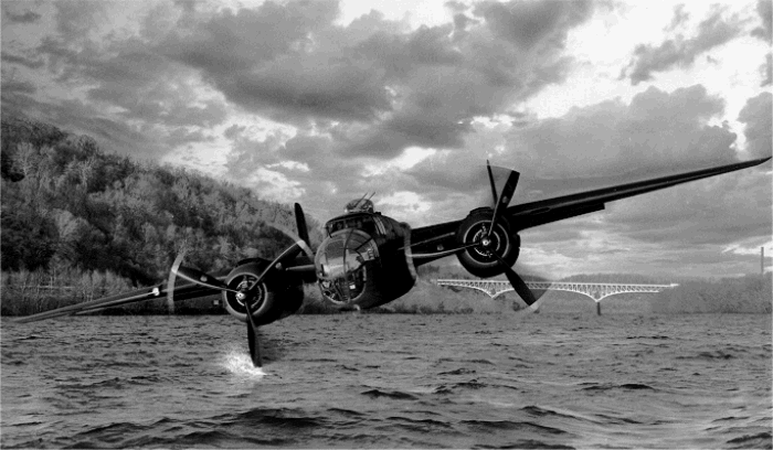 Image © 1994 Filmet Incorporated
|
||||||